Object ID:
2015.6.6
VE Exhibit Label 1:
CLICK EACH IMAGE TO READ THE ASSOCIATED INFORMATION
or view the same information below.
Each number below represents the information included on the associated image.
1
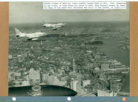
BELOW: F-86Hs of Mass Air Guard overfly Boston-town in Nov., 1959, formatting on our T-33A, so that these pix could be made. Note Central Artery is there, but many of the newer tall buildings are still in the future, in 1959!!!!!
=
2
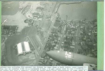
Paulsen was enjoying his second jet flight in less than a week today, over Logan!!!! This was my premier ride in a Lockheed T-33A. I'd get lotsa time in our 3 T'Birds. But today was really special, since my hands would have opportunity to feel what a "hi-tech" aircraft feels like in the air. FELT FANTASTIC, easy as pie to handle!!!!! I was shooting "official" pix at this moment, shortly after takeoff. Logan tower let us come in low (read that LOW!!!) for some views of our Air National Guard facility. Note below at Jeffries Point that the old trolly loop @ end of Webster ST has been covered up by 1954. I never realized that the roadway had been fixed that early!!!!!
=
3
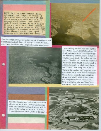
DATE: May, 1961 - During high altitude test flight in T-33A I shot this view of ANG area at BOS which shows old Wood Island Park remnant well indeed (see arrow). Wish I could locate my 4x5" neg!!! It is a fine view of Wood Island. By this time old beach is swallowed by MASSPORT's desire to enlarge the Logan Airport facilities again!!! (compare with earlier air views).
Note the orange arrow, which points out old Wood Island Park still remained virtually intact, though by CY 1954 the Harbor waters have been filled in to a large extent, one may observe.
LEFT: During Paulsen's very first flight in an F-94B (it was s/n 50867) I made an OK air view through the '94's curving canopy! We were away up there, maybe as high as 40K feet (undoubtedly the highest we ever got in a "Starfire", as I recall the occasion)! We needed all the height, found it tough to get the sluggish jet to climb much above, say 39K feet. Not really sure WHY??? We have the excellent 4x5" negative, must make some B&W slides from it some day! Guard Bureau wanted a high-altitude air view of our MASS ANG facility, so we sure obliged the "brass", of course!!! Note how the top print has "faced" to a warm-toned "sepia" color over the years!
RIGHT: This shot was made from much lower altitude; we are in an AT-6D as we shoot this AOK view of our MASS ANG apron, with the older F-84Bs parked below us, in CY 1950. ( was flying in our AT-6D, #017 at this time).
=
4
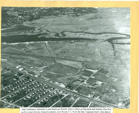
Julie Goldman's bailiwick is seen from our MASS ANG T-Bird, as Marshall and Paulsen flew low, as if to enter Revere Airport's pattern, over Route C-1. Note the fine "seaplane base", that almost became a reality here. Paulsen shot this image with our ANG-owned K-20 aerial camera (1954).


